Announcement: My online Land Navigation course includes four hours of video instruction, and two downloadable PDF books, all for about the same price as a typical paperback book. Get my Land Navigation course here.
Contour Lines
Contour lines depict elevation and relief on a map. Actually, you might call these lines "contour circles" because each such line is simply a closed loop that runs along a fixed elevation.
To Illustrate the Point
Imagine a hilltop completely covered in flood waters. Now, imagine the waters receding each few days, leaving stain marks periodically at each new lower water level around the increasingly-exposed hill. These stain marks are essentially contour lines--lines forming closed loops running along a fixed elevation.
Another Way to Illustrate the Point
- Imagine drawing a line all the way around the shore of a lake.
- Now, let’s imagine the lake’s waters receded somewhat. Draw a second line all the way around the new, smaller shore line.
- Let’s further imagine the shoreline receded even more. Draw a third line all the way around the latest shoreline.
The three circular lines you imagined drawing around the lake’s receding shoreline are essentially contour lines—closed loops running along a fixed elevation.
Contour Line Spacing
The spacing of the lines allows you to visualize changes in elevation and relief between them. Closely spaced contour lines show steep changes, whereas widely spaced lines show gradual changes.
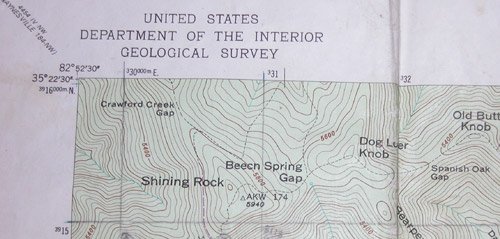
The following picture is a section of a well-worn USGS topo map, showing a part of North Carolina’s Shining Rock Quadrangle, a quite mountainous area.
Notice the brown contour lines depicting elevation and relief. Notice further three of the hilltops shown here: Shining Rock, Dog Loser Knob, and Old Butt Knob.
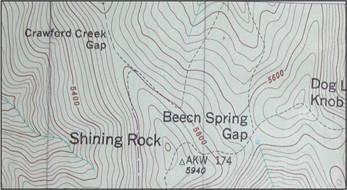
Notice that a hilltop is represented by a small, often irregular-shaped circle. That circle represents the amount of ground you'd see if flood waters were to rise to the elevation of the hill's highest contour line.
Contour Interval
The contour interval is the vertical distance represented between contour lines. Each map's contour interval can vary according to the values of elevation and relief that must be depicted. In relatively flat Florida, for instance, that distance may be as little as five feet. In mountainous areas, the contour interval may be 40 feet, or even 100 feet. Most, if not all, USGS topo maps state the contour interval in the map's margin.
Index Contours and Intermediate Contours
As seen in the picture below, each fifth contour line is called an Index Contour, and is heavier, or more bold, than other contour lines, which are called Intermediate Contours. Notice,for example, the 5800-foot contour line on the hill called Shining Rock.
Figuring A Hilltop's Elevation
This map's contour interval is 40 feet, meaning the next highest intermediate contour above the 5800-foot index is 5840. Then 5880, then 5920, 5960, and the final contour line near Shining Rock hill's apex is the index contour at 6000 feet. The very tip-top of the hill is considered to be half-way between the 6000-foot final contour and the 6040-foot contour (not shown because the hill isn't that high), or 6020 feet. So the top of Shining Rock is at 6020 feet elevation.
Contour Lines Make for Better Navigation
As you cross the terrain, contour lines can help you make better navigation decisions. All things being equal, it's usually better, for example, to "contour" around a hill than to go over it, and then descend again. The best route between two points, then, is not always the shortest.
Using contour lines helps you match up the terrain you see around you with what's shown on your map. Let's say, for example, you're on a ridge that slopes to the southeast. To help locate your position on the map, read the map's contour lines. Is there in your general area a ridge sloping to the southeast? Let's say there is, and further let's say there's only one. Congratulations! You've just identified the ridge you're on. While you may not have pinpointed your exact position, at least you know your general location. And many times, that's all you need to know.
Return from Contour Lines to Home