Announcement: My online Land Navigation course includes four hours of video instruction, and two downloadable PDF books, all for about the same price as a typical paperback book. Get my Land Navigation course here.
Map Scale
A map scale is the relationship of distance on the map to distance on the terrain.
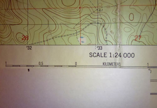
A USGS 7.5 quad topographical map, for instance, has a scale of 1:24,000, meaning that any given distance on the map equals 24,000 times that distance on the terrain. That map distance is often some convenient unit of measure, such as an inch or a centimeter.
- Example: One inch on the map equals 24,000 inches (2,000 feet) on the terrain.
- Example: One centimeter on the map equals 24,000 centimeters (240 meters) on the terrain.
US Military Maps and many Canadian and European maps use a scale of 1:25,000.
- Example: One centimeter on the map equals 250 meters on the terrain. Logically, then, four centimeters on the map equal 1,000 meters (one kilometer) on the terrain. Four centimeters per kilometer (sometimes called a klick for short) makes for convenient measuring when using a map with a 1:25,000 scale.
Other fairly common map scales are 1:62,500 and 1:100,000.
Large scale maps show more detail and less area. They provide a "zoomed in" view of the terrain.
Small scale maps show less detail, but more area. They provide a "zoomed out" view of the terrain.
It's easy to confuse large scale vs. small scale, but thinking of zoomed in vs. zoomed out should help you keep them straight.
Using the Map Scale to Measure Distance
Measuring Straight-Line Distances
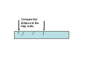
Measuring straight-line distances on a map is easy. Just find the map distance with a ruler or other straight edge, then compare that distance to one of the map's three bar scales--either the kilometers scale, the statute miles scale, or the nautical miles scale.
When looking at each bar scale, look for the primary scale and the extension scale.
The primary scale is used for measuring whole units--kilometers, statute miles, or nautical miles.
The extension scale is to the left of the primary scale, and is used for measuring fractions of units.
- Example: Using a straight piece of paper, you measured a distance on the map by making a mark on the paper at either end of the map distance measured. When comparing your marked paper to the map's kilometer scale, it's apparent the distance is longer than one kilometer, but less than two. To measure the fractions of the last kilometer accurately, you put one mark on the one-kilometer point on the primary scale. Your other mark will fall somewhere on the extension scale to the left. You'll see that the extension scale is divided into 10 units--100 meters per unit. Simply read off the extension scale the number and approximate fraction of each unit. In this case, we'll say you read off 650 meters. Your measured map distance, then is 1 full kilometer plus an additional 650 meters, or 1,650 meters.
Measuring Crooked-Line Distances
To measure distance along a crooked terrain feature such as a trail, place a long piece of paper next to some section of the trail that is straight enough to measure with the paper's straight edge. Then, draw tick marks along the fairly straight section of the trail.
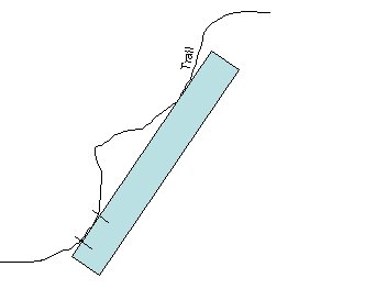
Next, turn the paper's straight edge to match it up as nearly as possible with some next trail distance that can be reasonably measured with a straight edge. Now, make new tick marks along this second section measured.
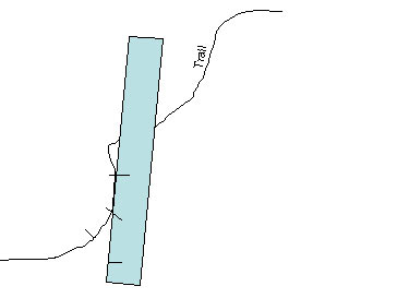
Do the same thing with a third section of the trail, followed by as many small fairly straight sections as you wish to measure, as long as the total measurements don't exceed your paper's length.
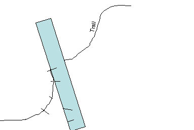
Finally, compare the distance from the first to the final tick mark against the map's bar scale to get the actual distance between the two map points.