Announcement: My online Land Navigation course includes four hours of video instruction, and two downloadable PDF books, all for about the same price as a typical paperback book. Get my Land Navigation course here.
Geographic Coordinates
Geographic coordinates are values given for intersecting latitude and longitude lines, and can be use to identify any place on earth.
When stated in combination, the numerical value of each line constitutes an identifiable geographic "address."
This geographic address--that is, these coordinates--allows you to communicate effectively by cell phone, satellite phone, or radio your exact position on earth. Doing so might be particularly important in a distress situation. A 911 call from the backwoods, for instance, goes much better if you can accurately state your specific lat/long coordinates rather than offer only imprecise directional information: "We're over here by a big tree near some creek."
Lat before Long -- Customarily, the latitude--hemisphere and value--is given first, followed by the longitude--hemisphere and value. Sometimes the hemisphere precedes the value, and sometimes it follows the value.
- Hemisphere precedes -- N 30 degrees, W 110 degrees
- Hemisphere follows -- 30 degrees N, 110 degrees W
Since longitude values can be three digits (up to 180 degrees), a place-holding zero is often stated when the value is only two digits.
- Example: N 30 degrees, W 080 degrees
Three ways to express lat/long values
People sometimes express the same lat/long value in one of three different ways:
- Decimal Degrees: N 26.7717 degrees, W 079.9583 degrees
- Degrees, Decimal Minutes: N 26 degrees 46.30 minutes, W 079 degrees 57.5 minutes
- Degrees, Minutes, Decimal Seconds: N 26 degrees 46 minutes 18 seconds, W 079 degrees 57 minutes 29.88 seconds
Converting from one Lat/long Value to Another
To make the conversion, you're either going to multiply or divide by 60. For example, if you want to change a decimal to minutes and/or seconds, you'll multiply, as follows:
26.7717 degrees =
26 degrees + 0.7717 x 60 minutes =
26 degrees 46.30 minutes =
26 degrees 46 minutes + .30 x 60 seconds=
26 degrees 46 minutes 18 seconds
On the other hand, if you want to change minutes and or seconds to a decimal of minutes or degrees, you'll divide, as follows:
26 degrees 46 minutes 18 seconds=
26 degrees 46 + 18/60 minutes=
26 degrees 46.30 minutes=
26 degrees + 46.30/60 degrees=
26.7717 degrees
Lat/long and the USGS 7.5 Quad Topo Maps
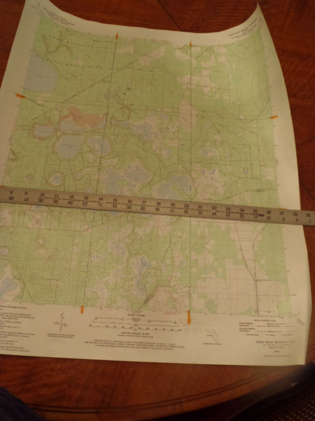
A USGS 7.5 quad topographic map covers a quadrangle of the earth's surface measuring 7.5 minutes of latitude by 7.5 minutes of longitude.
While the lat/long grid is not printed on the face of these maps, there are latitude and longitude tick marks in the margins appearing every 2.5 minutes.
Using a yardstick or other long straight edge, you can connect these tick marks with straight lines, creating a nine-block, tic-tac-toe-like grid on the map's face. This grid, along with the proper map tool, can be used to obtain accurate geographic (i.e. lat/long) coordinates of any place on the map.
Using a Map Tool to Measure Geographic Coordinates
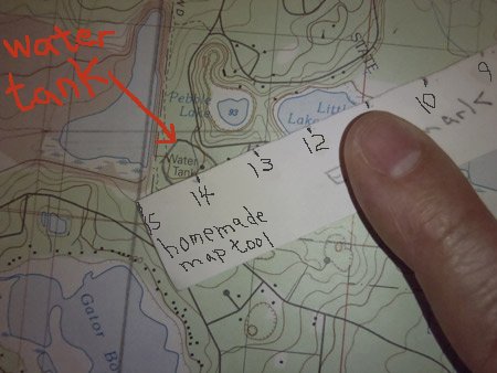
The map tool referred to above is a home-made ruler-like instrument with 15 equally spaced markings for taking measurements (see photo just below). Since there are 2.5 minutes--i.e.150 seconds--between each grid line, the map tool's markings represent 10 seconds each.
To make this map tool, use a stiff piece of paper to which you add the 15 equally spaced markings by using a ruler to measure between the latitude lines of your map's grid which you've drawn in using the lat/long tick marks. Whatever that measurement is, divide by 15 and use the ruler to make marks on your map tool. Once you've made one map tool, you can use it as a template for making others.
Increments of latitude are the same as increments of longitude only at the Equator. Away from the Equator, longitude lines continuously get closer together as you go toward the poles, meaning your grid "squares" are not squares at all, but somewhat irregular rectangular shapes.
Measuring Latitude
To measure these irregular rectangles for purposes of obtaining coordinates, lay one end of the map tool--i.e. the "0" mark--on the latitude line below your target. The tool's "15" mark should be on the latitude line above your target.

In this example, we want to find the geographic coordinates of the water tank at Gold Head Branch State Park in Florida. To make your target easier to identify, notice that two photos above, the water tank's position on the map is indicated with a red arrow.
Now, count the marks from the latitude grid line below your target up to your target. To that latitude grid line's value, add 10 seconds for every tick mark counted.
In this case, the value of the latitude grid line in question is 29 degrees 47 minutes 30 seconds North. You count 11 tick marks up to your target. You therefore add 110 seconds (11 tick marks x 10 seconds for each tick mark) to 29-47-30 North. Remembering that there are 60 seconds to a minute, the sum will be 29-49-20 North. So, that's your latitude for the water tower: 29 degrees 49 minutes 20 seconds North.
Measuring Longitude
Next, measure longitude in a similar manner. Except this time--unless you're at the Equator--you'll have to angle the tool so both the "0" and the "15" marks are touching the grid's longitude lines encompassing your target.
Now, count off the incremental distance to your target from the easternmost longitude grid line encompassing the target. It doesn't matter that the map tool is angled. The tool still divides the distance between longitude lines into 15 equal parts, and that's what you want.
Add the incremental distance to the value of your longitude grid line, and you have your longitude.
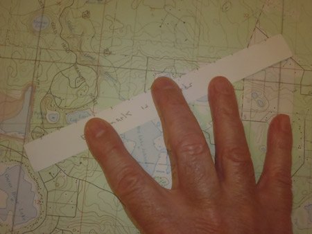
In this case, the value of the longitude grid line to the east of your target is 081 degrees 55 minutes West, or 081-55-00 W. Having placed your map tool on each longitude grid line encompassing your target, you count 14 tick marks over to the water tank. You therefore add 140 seconds (14 tick marks x 10 seconds per tick mark) to 081-55-00 W. Remembering there are 60 seconds in a minute, the sum is 081-57-20 W, or 081 degrees 57 minutes 20 seconds West.
So, now you have the geographic coordinates for the water tank: 29 degrees 49 minutes 20 seconds North, 081 degrees 57 minutes 20 seconds West.
It took a lot of work, but you did it. The amount of work it takes to find geographic coordinates (i.e. lat/long coordinates) on USGS topo maps is one reason land navigators prefer the UTM grid, which is much, much easier to work with.
Lat/long is Mostly for Mariners
Lat/long is regularly used with marine charts (a chart is a map used for maritime purposes, but no self-respecting mariner calls his chart a "map").
For ease of measuring, a marine chart normally depicts lat/long grid lines, along with a lat/long scale in minutes and tenths of minutes along the chart's edges. The grid lines are used in conjunction with the lat/long edge scales to find geographic coordinates with relative ease, especially with a pair of dividers, an instrument made for that purpose.
As for distance measurement, mariners think in terms of nautical miles because of the convenient correspondence of one nautical mile to one minute of latitude.
As you can see, lat/long is fine for mariners partly because of what's shown on the charts. For us ground pounders, however, while we may be able to draw in a lat/long grid on our maps, the lat/long edge scales aren't depicted, making obtaining geographic coordinates a somewhat tricky exercise, thus making lat/long a bit hard to work with.
Return from Geographic Coordinates to Latitude and Longitude