Announcement: My online Land Navigation course includes four hours of video instruction, and two downloadable PDF books, all for about the same price as a typical paperback book. Get my Land Navigation course here.
Resection
Resection involves identifying on the terrain at least two mapped features--for example, a mountain top and a radio tower--and determining the direction of each relative to you.
That direction can be expressed as a compass bearing from your position to each of the mapped features. Each of these bearings from your position is a compass line of position. Where those lines of position cross is where you are.
Example: While traveling through mountainous terrain, you recognize two mountain peaks in the distance--Rocky Top and Old Smokey.
Step 1. Using your compass, you determine the bearing to each peak.
- As you can see from the illustration below, the bearing to Rocky Top is 025 degrees Magnetic, and the bearing to old Smokey is 090 degrees Magnetic.

Pointer
When using resection, try to have at least 45 degrees difference between the way the distance terrain features line up. With two terrain features, ideally they would be 90 degrees apart. With three terrain features, ideally they would be 60 degrees apart from one another. Of course, ideal situations seldom occur, so 45 degrees is a good number to shoot for. If your terrain features line up too closely, you lose accuracy in fixing your position. If they line up perfectly--that is the are exactly 180 degrees apart--you can't fix your position at all.
Step 2. Convert the Magnetic bearings in Step 1 to True Bearings.
- We'll say the declination is 007 degrees West. As you'll recall from the video on the magnetic declination page:
When the declination is West, Magnetic bearings will ALWAYS be larger than true bearings.
So, elementary logic says that you must SUBTRACT THE DECLINATION from the Magnetic bearings to get the True bearings, as follows:
025M - 007 = 018T and 090M - 007 = 083T
Haven't seen the page on magnetic declination? Wow. That's important stuff. Now might be a good time to go learn what's there if you don't already understand declination. Be sure to watch my 14-minute instructional video. Don't worry. I'll be here when you get back.
Step 3. On your map, draw an 18-degree line through Rocky Top, and and 83-degree line through Old Smokey.
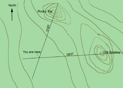
There's only one place on earth where you can see Rocky Top in the distance at 018 degrees and Old Smokey at 083 degrees True. And that's exactly where you are, as shown by the convergence of your two lines.
Modified Resection
"It takes two, baby. It takes two, baby. It takes two." Excuse me, I guess I got carried away.
But that song title reminds me that it only takes two--two lines of position that is, to pinpoint yourself on the map. If it so happens that you're already traveling along a line of position (a road, river, trail, whatever), you can fix your position if you can come up with only one more.
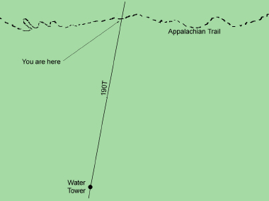
Example: While traveling along the Appalachian Trail in north Georgia, you spot a water tower which you identify on the map as the water tower at Camp Merrill--the U.S. Army Ranger training post. Fix your position as follows:
Step 1. Determine the compass bearing to the water tower, in this case, we'll say it's 195 degrees.
Step 2. Convert your Magnetic bearing to a True bearing. Since the declination in this part of the world is 005 degrees West, the True bearing to the water tower is 190 degrees.
Step 3. On your map, draw a 190 degree line through the water tower. You're located where that line crosses the Appalachian Trail.